Land Survey and GIS
All the most necessarily in Land SurveyingLand Survey and GIS
All the most necessarily in Land Surveyingdefinition latitude and longitude
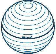
Latitude

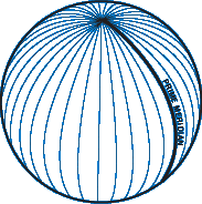
Longitude

With this saying in my mind, I picture all of the longitudinal meridians meeting at the poles, each meridian the same length as the next.
Symbols for degrees, minutes and seconds:
° | Degrees |
' | Minutes |
" | Seconds |
The three common formats:
| DDD° MM' SS.S" | Degrees, Minutes and Seconds |
| DDD° MM.MMM' | Degrees and Decimal Minutes |
| DDD.DDDDD° | Decimal Degrees |
Degrees, Minutes and Seconds
Degrees and Decimal Minutes
This is the format most commonly used when working with electronic navigation equipment.
![]()
Decimal Degrees
This is the format you'll find most computer based mapping systems displaying. The coordinates are stored internally in a floating point data type, and no additional work is required to print them as a floating point number.
Often the N-S and E-W designators are omitted. Positive values of latitude are north of the equator, negative values to the south. Watch the sign on the longitude, most programs use negative values for west longitude, but a few are opposite. This saves a lazy western hemisphere programmer from having to type in a minus sign before most of their longitude values.
![]()
Which format should you use?
First off, if you are working with other people who have agreed upon a format to use, then you should probably use that format.
Next, you will want to look at the maps, lists of coordinates, and any software you may be using. If you can find a consistent format among them, your work will be easier.
You can set your GPS to display any one of these three formats. Locations can be entered into the GPS with the selected format, and then by switching the display format setting, viewed in a different format.
I frequently choose to use the Degrees and Decimal Minutes format, even though the USGS maps I'm using are marked in Degrees, Minutes and Seconds. The markings on the map are all at either 0, 15, 30, or 45 seconds. By remembering the "quarter minute conversions" of 0.00, 0.25, 0.50, and 0.75, I can quickly do the conversions in my head.